Science
Conic projection
A map made by projecting lines from a globe onto a cone. Conic projection is a method in cartography where the Earth's surface is projected onto a conical surface, helping to accurately represent mid-latitude areas.
Contour interval
The difference in elevation between two contour lines. Contour interval. In Science, a contour interval is the vertical distance or difference in height between successive contour lines on a map, showing the slope of the terrain.
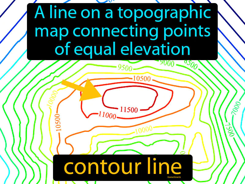
Contour line
A line on a topographic map connecting points of equal elevation. Contour line. A contour line shows areas at the same height above sea level, helping to visualize the 3D shape of the landscape on a flat map.
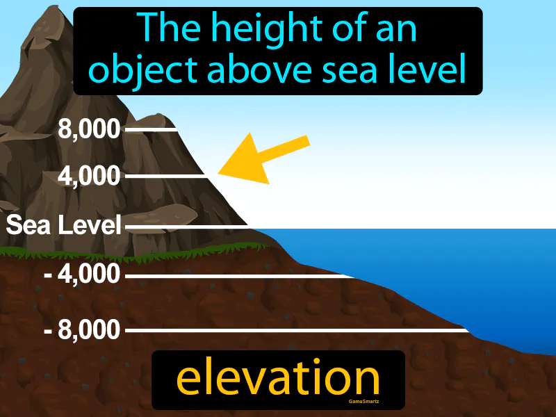
Elevation
The height of an object above sea level. Elevation. Elevation is the height or altitude of a place or object measured from sea level.
Equator
A line running east to west around the center of the Earth. Equator. The equator is an imaginary line that divides the Earth into the Northern and Southern Hemispheres.
Gps
A system of satellites that enable the receiver to determine their location global positioning system. GPS. GPS is a network of satellites that helps you find your exact location on Earth.
Index contour
On a map, the heavy contour line labeled with the elevation. Index contour. An index contour is a thicker line on a map that shows elevation and helps you easily identify height levels in terrain.
Landform
A natural land feature, like valleys, hills or plains. Landform. A landform is a natural shape or feature on the Earth's surface, like a mountain or valley.
Latitude
The distance in degrees north or south of the equator. Latitude. Latitude is an imaginary line that measures how far a location is from the equator.
Longitude
The distance in degrees east or west of the prime meridian. Longitude. Longitude is a geographic coordinate that specifies the east-west position of a point on Earth's surface.
Map
A representation of the Earth's surface. Map. A map is a visual tool that shows the features and layout of an area, helping us understand locations and distances.
Map legend
Explains the meaning of symbols used on a map. Map legend. In Science, a map legend is like a key that helps you understand what different symbols on a map represent.
Map scale
The relationship between distances on a map and distances on Earth's surface. Map scale. Map scale shows how much smaller a map is compared to the real world.
Plain
A landform of flat land with low relief. Plain. A plain is a large area of flat or gently rolling land with few changes in elevation.
Plateau
A flat raised landform with a nearly level surface. Plateau. In Science, a plateau is an elevated flat area where a process or activity remains steady and unchanged.
Prime meridian
A line running north to south around the center of the Earth. Prime meridian. The prime meridian is the imaginary line that divides the Earth into the eastern and western hemispheres.
Relief
Difference in elevation between the high and low parts of an area. Relief. In Science, relief refers to the variations in height and slope of the Earth's surface.
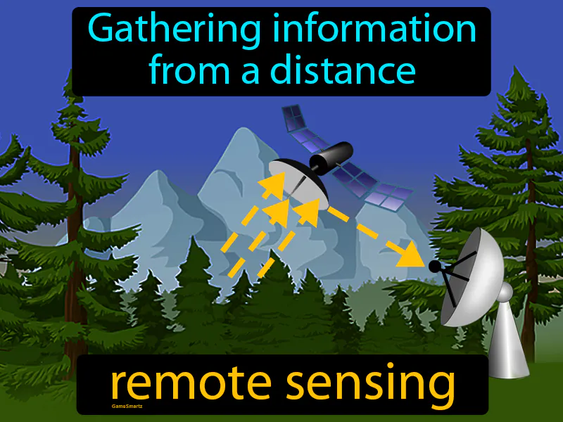
Remote sensing
Gathering information from a distance. Remote sensing. Remote sensing is the use of satellites or aircraft to collect data about the Earth's surface without making physical contact.
Topographic map
A map showing Earth's surface features and elevations. Topographic map. A topographic map shows the shape and height of the land using contour lines.
Topography
The study of the shape of the land determined by elevation and landforms like mountains, rivers, and valleys. Topography. Topography is the study of the features and shapes of Earth's surface.